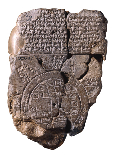
It was drawn on clay. Known as the Imago Mundi, it's the oldest Babylonian world map known to us today, commonly dated to the 6th century BCE.
Imago Mundi via kwout
Imago Mundi is a diagrammatic labeled depiction of the known world from the perspective of Babylonia. The map is incised on a clay tablet, showing Babylon somewhat to the north of its center; the clay tablet is damaged, and also contains a section of cuneiform text.
It is usually dated to the 5th century BC. It was discovered at Sippar, southern Iraq, 60 miles (97 km) north of Babylon on the east bank of the Euphrates River, and published in 1899. The clay tablet resides at the British Museum(BM 92687).
It is conjectured that the island locations, though possibly referring to real areas, may also represent a mythological interpretation of the world.
See information on maps of different periods in the history from Armenica.org.